Schlacht von Bosworth Field

Battle of Bosworth Field
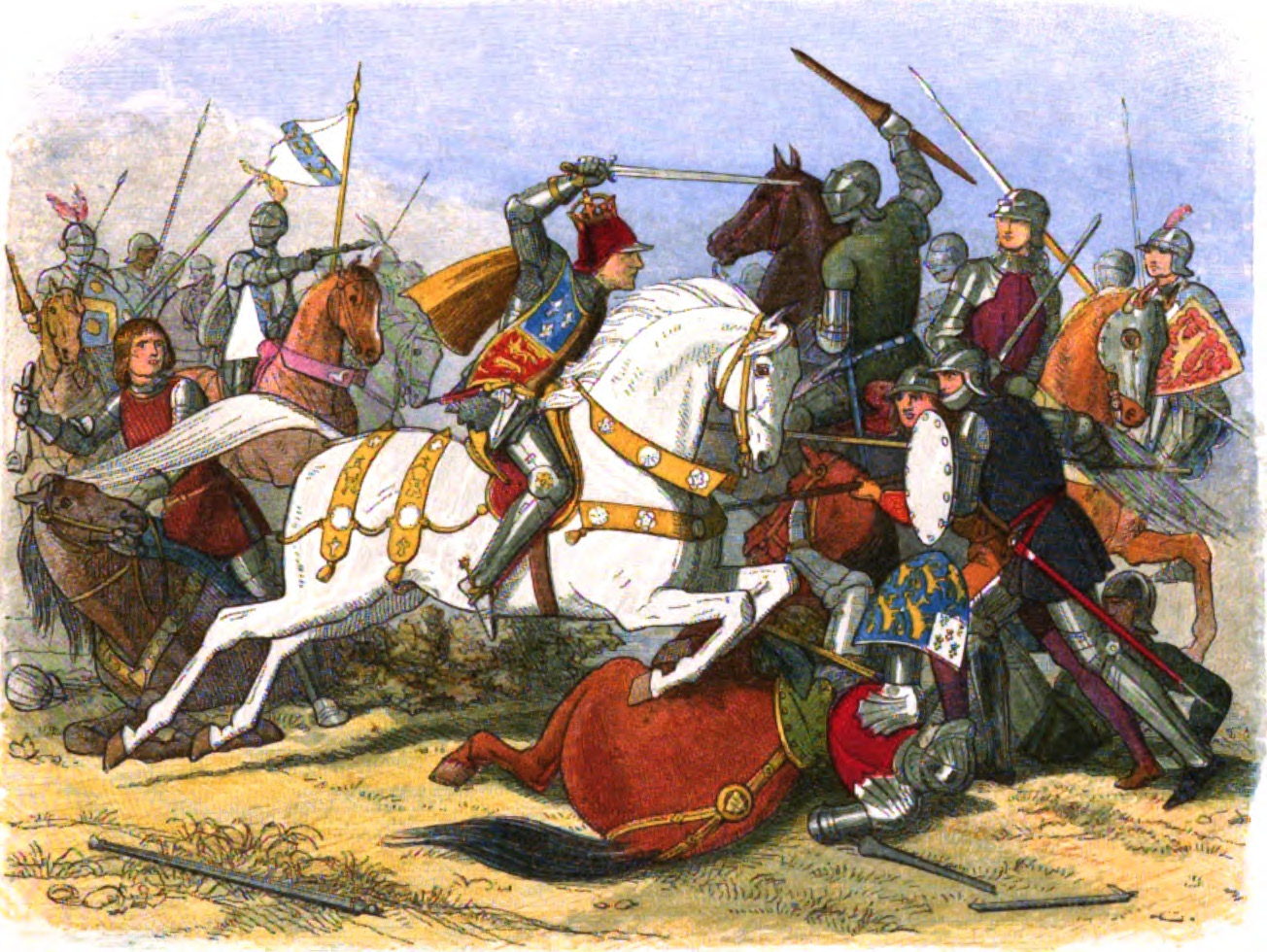
Richard III in action at the Battle of Bosworth Field.

Bosworth Field: Richard III and Henry Tudor engage in battle, prominently in the centre
Looking south-west from close to the point where Richard III's standard flies. There are now far more trees in the scene than would have been the case in 1485. From here an approaching army using Fenn Lanes would have been visible. Dadlington windmill would also have been visible: almost certainly the place where Richard III's senior commander the Duke of Norfolk, was slain (according to the Stanley ballad, "Lady Bessy"). Dadlington windmill stood somewhere between Apple Orchard Farm and neighbouring North Farm. One of the fields of North Farm, just north of Apple Orchard Farm, was still called Mill Field on a mid C19th tithe map.
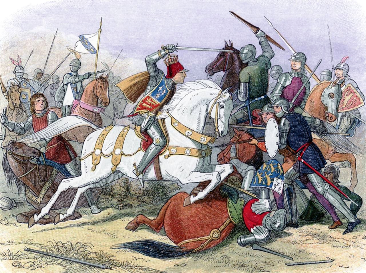
King Richard III at Bosworth Field. This engraving was published in: Doyle, James William Edmund (1864) "Richard III" in A Chronicle of England: B.C. 55 – A.D. 1485, London: Longman, Green, Longman, Roberts & Green, pp. p. 453 Retrieved on 12 November 2010.

Bosworth Battlefield Heritage Centre's model diorama of the Battle of Bosworth Field, installed since its establishment in 1974.

Re-enactment of the 500th anniversary of Henry Tudor's (Henry VII) march through Newport from Wales via Muster Hill to the Battle of Bosworth in 1485.

Illustrations and photographs of places and events in Welsh history from a childrens book called 'Flame Bearers of Welsh History'
Battle of Bosworth - Engraving
![Looking west from Fox Covert Lane across the fields of Fenn Lane Farm (the farm is left, on the skyline). Fen Hole is approximately where the hedge line in the foreground is. The cortege carrying Richard III's remains visited the farm and soil was taken and placed in the king's grave when he was re-buried in Leicester Cathedral in 2015. The fields on either side of Fenn Lanes Roman road correspond to the flat plain which William Burton (writing in the early 1600s) described as the site of the battle: "fought in a large, flat, plaine, and spacious ground, three miles distant from [Bosworth], between the Towne of Shenton, Sutton [Cheney], Dadlington and Stoke [Golding]..," It was in the fields to either side of Fenn Lanes (the route of approach of Richmond's army) that the Battlefields Trust found the round shot and silver-gilt boar badge, identifying the true site of the battle. (Ambion Hill was the site of Richard III's camp, not the site of the battle).](https://upload.wikimedia.org/wikipedia/commons/9/97/Bosworth_Battlefield_%28Fenn_Lane_Farm%29.jpg)
Looking west from Fox Covert Lane across the fields of Fenn Lane Farm (the farm is left, on the skyline). Fen Hole is approximately where the hedge line in the foreground is. The cortege carrying Richard III's remains visited the farm and soil was taken and placed in the king's grave when he was re-buried in Leicester Cathedral in 2015. The fields on either side of Fenn Lanes Roman road correspond to the flat plain which William Burton (writing in the early 1600s) described as the site of the battle: "fought in a large, flat, plaine, and spacious ground, three miles distant from [Bosworth], between the Towne of Shenton, Sutton [Cheney], Dadlington and Stoke [Golding]..," It was in the fields to either side of Fenn Lanes (the route of approach of Richmond's army) that the Battlefields Trust found the round shot and silver-gilt boar badge, identifying the true site of the battle. (Ambion Hill was the site of Richard III's camp, not the site of the battle).

Henry VII Crowned in Bosworth Field

Looking north-east from Fenn Lanes Roman road in the direction of Shenton. This photo was taken from a field entrance a short distance east of Fenn Lane Farm. The trees on the skyline belong to Greenhill Covert (beyond which lies the Sence Brook)and Ambion Hill, with Ambion Wood visible at right. The first find of round shot from the battle was made in a field to the west of Mill Lane, the road leading from Fenn Lanes Roman road towards Shenton. Subsequently many further finds of artillery shot have proved that the fields lying north and south of Fenn Lanes are the true location of the fighting on 22 August 1485. This location is in the area suggested by historian William Burton.
![Looking south-east from Fenn Lane Roman road, across the fields of Fenn Lane Farm. It was from this vicinity that soil was taken and placed in Richard III's grave when he was re-buried in Leicester Cathedral in 2015. The fields on either side of Fenn Lanes correspond to the flat plain which William Burton (writing in the early 1600s) described as the site of the battle: "fought in a large, flat, plaine, and spacious ground, three miles distant from [Bosworth], between the Towne of Shenton, Sutton [Cheney], Dadlington and Stoke [Golding]..," It was in the fields to either side of Fenn Lanes (the route of approach of Richmond's army) that the Battlefields Trust found the round shot and silver-gilt boar badge, identifying the true site of the battle. (Ambion Hill was the site of Richard III's camp, not the site of the battle). The spire of Stoke Golding church is on the horizon. Henry VII was crowned on (what came to be known as) Crown Hill, Stoke Golding.](https://upload.wikimedia.org/wikipedia/commons/b/be/Bosworth_Battlefield_true_location.jpg)
Looking south-east from Fenn Lane Roman road, across the fields of Fenn Lane Farm. It was from this vicinity that soil was taken and placed in Richard III's grave when he was re-buried in Leicester Cathedral in 2015. The fields on either side of Fenn Lanes correspond to the flat plain which William Burton (writing in the early 1600s) described as the site of the battle: "fought in a large, flat, plaine, and spacious ground, three miles distant from [Bosworth], between the Towne of Shenton, Sutton [Cheney], Dadlington and Stoke [Golding]..," It was in the fields to either side of Fenn Lanes (the route of approach of Richmond's army) that the Battlefields Trust found the round shot and silver-gilt boar badge, identifying the true site of the battle. (Ambion Hill was the site of Richard III's camp, not the site of the battle). The spire of Stoke Golding church is on the horizon. Henry VII was crowned on (what came to be known as) Crown Hill, Stoke Golding.

Battlefield map of the Battle of Bosworth Field, 22 August 1485, showing the last stages of the engagement: Richard III charges Richmond's small force. William Stanley charges into the fray on Richmond's side, forcing Richard against a marsh. Surrounded, outnumbered, and on foot, Richard dies in combat.

Battlefield map of the Battle of Bosworth Field, 22 August 1485, showing the initial force positions

Stone at the supposed point of death of King Richard III at the Battle of Bosworth in 1485. Plaque reads "Richard the last Plantaganet King of England was slain here 22nd August 1485"

Crowning Henry VII After the Battle of Bosworth

הפלישה של הנרי השביעי לאנגליה, עד קרב בוסוורת'.

The march of Henry Tudor (later Henry VII) and Rhys ap Thomas through Wales, to Bosworth field. The dates shown are nights staid at the location. CoA of Owen Tudor: https://commons.wikimedia.org/wiki/File:Arms_of_Owen_Tudor.svg by User:Sodacan CoA of Rhys ap Thomas: https://commons.wikimedia.org/wiki/File:COA_Sir_Rhys_ap_Thomas.svg by User:AlexD Map (File:Wales relief location map.jpg): https://commons.wikimedia.org/wiki/File:Wales_relief_location_map.jpg by Nilfanion

Just after winning the Battle of Bosworth Field, Henry VII is crowned atop Crown Hill, Stoke Golding, Leicestershire, United Kingdom.

Henry VII Crowned in Bosworth Field

IdentificatieTitel(s): Het lijk van Richard III, koning van Engeland, gevonden op het slagveld van Bosworth, 1485Objecttype: tekening Objectnummer: RP-T-1898-A-4040VervaardigingVervaardiger: tekenaar: Charles RochussenDatering: 1866Fysieke kenmerken: zwart krijtMateriaal: papier krijt Afmetingen: h 590 mm × b 860 mmOnderwerpWat: battle (+ land forces), namen van steden en dorpenhistorical events and situations (1485), historical person (RICHARD III, koning van Engeland) - scene directly related with life or life-story (RICHARD III, koning van Engeland)Wanneer: 1485 - 1485Waar: BOSWORTHWie: Richard III (koning van Engeland)Verwerving en rechtenCredit line: Legaat van de heer D. Franken, Le VésinetVerwerving: legaat dec-1898Copyright: Publiek domein
Historische Übersicht
Tod von Richard III. und Ende der Plantagenet-Dynastie; Aufstieg der Tudors.
Fakten auf einen Blick
Haus Tudor (Lancaster)
- Befehlshaber: Henry Tudor
- Truppenstärke: ca. 5.000
- Verluste: ca. 100
Haus York
- Befehlshaber: Richard III. †
- Truppenstärke: ca. 10.000
- Verluste: ca. 1.000
Strategischer Kontext
Heinrich Tudors Invasion zur Beendigung der Herrschaft von Richard III.
Konflikt / Krieg
Rosenkriege
Weiterführende Literatur


Historische Orte
Die interaktive Karte erfordert die Zustimmung zu Drittanbieter-Cookies.